


NOAA’s 2018 hurricane outlook was published in May, just before the official start of the hurricane season.
Neil Jacobs, the assistant secretary of commerce for environmental prediction and observation, says that NOAA predicts between 10 and 16 named storms, with sustained winds of 39 mph or higher. The agency expects five to nine hurricanes, which have winds of 74 mph or higher. One to four of those is expected to be major hurricanes — Category 3 or higher.
NOAA and the Federal Emergency Management Agency recommend that members of the public make emergency and evacuation plans, and review their insurance coverage.
As many remember, 2017 was a very active and extreme season. NOAA initially predicted an extremely active season, forecasting 11 to 17 named storms with up to nine hurricanes. The 2017 season went down on the record as having 17 named storms, including 10 hurricanes. Last year, NOAA slightly underestimated just how intense the hurricanes would be. It expected two to four major hurricanes; in fact, there were six major hurricanes, three of which made landfall as powerful storms.
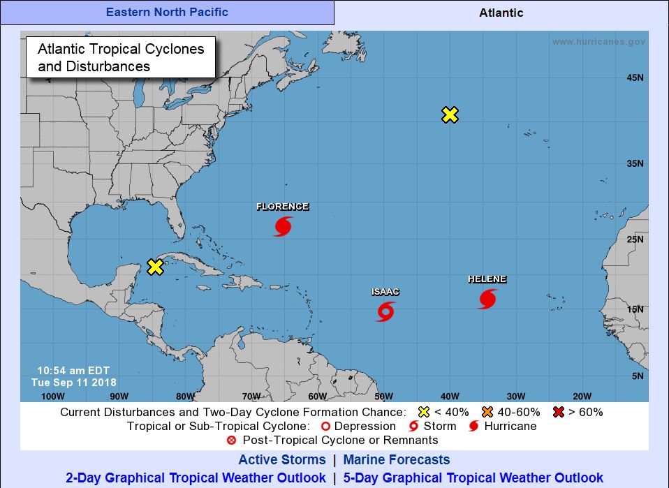
The 2018 season became quite active in the second week of September. Hurricane Florence, Tropical Storm Isaac, and Hurricane Helene developed, their paths monitored through data from satellites and an Air Force Reserve reconnaissance aircraft missions.
What is a ‘Typical’ Hurricane Season?
Each year, an average of ten tropical storms develop over the Atlantic Ocean, Caribbean Sea, and the Gulf of Mexico. Many of these remain over the ocean. Six of these storms become hurricanes each year. In an average 3-year period, roughly five hurricanes strike the United States coastline anywhere from Texas to Maine. Of these, two are typically major hurricanes (winds greater than 110 mph).
Looking back over the past 100 years, we have had some intense hurricane seasons and intense hurricanes. Here is a look at the most active seasons.
Hurricane Categories 1-5
The Saffir-Simpson Hurricane Wind Scale is a 1 to 5 rating based on a hurricane’s sustained wind speed. This scale estimates potential property damage. Hurricanes reaching Category 3 and higher are considered major hurricanes because of their potential for significant loss of life and damage. Harvey was a Category 4 hurricane; Irma, a Category 5 hurricane. Category 1 and 2 storms are still dangerous, however, and require preventative measures. In the western North Pacific, the term “super typhoon” is used for tropical cyclones with sustained winds exceeding 150 mph.
| Category | Sustained Winds | Types of Damage Due to Hurricane Winds |
|---|---|---|
| 1 | 74-95 mph 64-82 kt 119-153 km/h | Very dangerous winds will produce some damage: Well-constructed frame homes could have damage to roof, shingles, vinyl siding and gutters. Large branches of trees will snap and shallowly rooted trees may be toppled. Extensive damage to power lines and poles likely will result in power outages that could last a few to several days. |
| 2 | 96-110 mph 83-95 kt 154-177 km/h | Extremely dangerous winds will cause extensive damage: Well-constructed frame homes could sustain major roof and siding damage. Many shallowly rooted trees will be snapped or uprooted and block numerous roads. Near-total power loss is expected with outages that could last from several days to weeks. |
| 3 (major) | 111-129 mph 96-112 kt 178-208 km/h | Devastating damage will occur: Well-built framed homes may incur major damage or removal of roof decking and gable ends. Many trees will be snapped or uprooted, blocking numerous roads. Electricity and water will be unavailable for several days to weeks after the storm passes. |
| 4 (major) | 130-156 mph 113-136 kt 209-251 km/h | Catastrophic damage will occur: Well-built framed homes can sustain severe damage with loss of most of the roof structure and/or some exterior walls. Most trees will be snapped or uprooted and power poles downed. Fallen trees and power poles will isolate residential areas. Power outages will last weeks to possibly months. Most of the area will be uninhabitable for weeks or months. |
| 5 (major) | 157 mph or higher 137 kt or higher 252 km/h or higher | Catastrophic damage will occur: A high percentage of framed homes will be destroyed, with total roof failure and wall collapse. Fallen trees and power poles will isolate residential areas. Power outages will last for weeks to possibly months. Most of the area will be uninhabitable for weeks or months. |
Hurricanes, Cyclones, and Typhoons
The only difference between a hurricane, a cyclone, and a typhoon is the location where the storm occurs. Hurricanes, cyclones, and typhoons are all the same weather phenomenon; we just use different names for these storms in different places. In the Atlantic and Northeast Pacific, the term “hurricane” is used. The same type of disturbance in the Northwest Pacific is called a “typhoon” and “cyclones” occur in the South Pacific and the Indian Ocean.
Other Hurricane Facts
- The eye of the storm is easy to identify on radar and satellite but the track of the storm is not easy to predict. Hurricanes are immense systems and morph in size, intensity, speed, and direction. Oceanic and atmospheric interactions impact both the path, speed and intensity of the hurricane.
- The east quadrant of a hurricane is typically the most dangerous in terms of storm surge, winds, and tornadoes. Learn more about the quadrants of hurricanes.
- Typical hurricanes are about 300 miles wide although they can vary considerably in size.
- The eye at a hurricane’s center is a relatively calm, clear area approximately 20-40 miles across.
- The eyewall surrounding the eye is composed of dense clouds that contain the highest winds in the storm.
- The storm’s outer rainbands (often with hurricane or tropical storm-force winds) are made up of dense bands of thunderstorms ranging from a few miles to tens of miles wide and 50 to 300 miles long.
- Hurricane-force winds can extend outward to about 25 miles in a small hurricane and to more than 150 miles for a large one. Tropical storm-force winds can stretch out as far as 300 miles from the center of a large hurricane.
Source: National Oceanic and Atmospheric Administration (NOAA)
To learn more about Vertex’s Catastrophic Response Services or to speak with a Forensic Expert, call 888.298.5162 or submit an inquiry.