


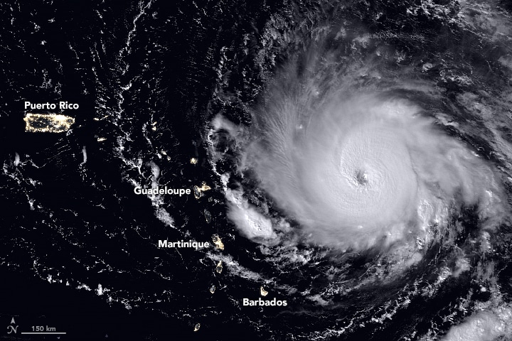
It is obvious that we are in the midst of a very active and dangerous hurricane season. The development of consecutive storms: Harvey, Irma, Jose, Katia, has a lot of people asking questions. Many are also struck by the intensity of the 2017 hurricane season. Harvey had record breaking rainfall with 51.88″ recorded. That’s now the greatest amount of rainfall over land for a single storm in continental U.S. history. Irma had sustained winds of 185 mph for over 35 hours, the highest in recorded history for an Atlantic Ocean hurricane.
The Hurricane Season
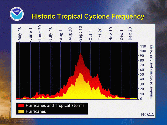
In the Northern Atlantic Ocean, there is a distinct hurricane season from June 1 to November 30. There is a sharp peak from late August through September. The graphic below, provided by NOAA, shows the spike around September 10th.
While 97 percent of tropical activity occurs during hurricane season, hurricanes have occurred outside of these six months.
The ingredients for these storms include a pre-existing weather disturbance, warm tropical oceans, moisture, and relatively light winds. If the right conditions persist long enough, they can combine to produce the violent winds, incredible waves, torrential rains, and floods we associate with this phenomenon.
A ‘Typical’ Hurricane Season
Each year, an average of ten tropical storms develop over the Atlantic Ocean, Caribbean Sea, and Gulf of Mexico. Many of these remain over the ocean. Six of these storms become hurricanes each year. In an average 3-year period, roughly five hurricanes strike the United States coastline anywhere from Texas to Maine. Of these, two are typically major hurricanes (winds greater than 110 mph).
Looking back over the past 100 years, we have had some intense hurricane seasons and intense hurricanes. Here is a look at the most active seasons.
A Category 5 Hurricane
The Saffir-Simpson Hurricane Wind Scale is a 1 to 5 rating based on a hurricane’s sustained wind speed. This scale estimates potential property damage. Hurricanes reaching Category 3 and higher are considered major hurricanes because of their potential for significant loss of life and damage. Harvey was a Category 4 hurricane; Irma, a Category 5 hurricane. Category 1 and 2 storms are still dangerous, however, and require preventative measures. In the western North Pacific, the term “super typhoon” is used for tropical cyclones with sustained winds exceeding 150 mph.
| Category | Sustained Winds | Types of Damage Due to Hurricane Winds |
|---|---|---|
| 1 | 74-95 mph 64-82 kt 119-153 km/h | Very dangerous winds will produce some damage: Well-constructed frame homes could have damage to roof, shingles, vinyl siding and gutters. Large branches of trees will snap and shallowly rooted trees may be toppled. Extensive damage to power lines and poles likely will result in power outages that could last a few to several days. |
| 2 | 96-110 mph 83-95 kt 154-177 km/h | Extremely dangerous winds will cause extensive damage: Well-constructed frame homes could sustain major roof and siding damage. Many shallowly rooted trees will be snapped or uprooted and block numerous roads. Near-total power loss is expected with outages that could last from several days to weeks. |
| 3 (major) | 111-129 mph 96-112 kt 178-208 km/h | Devastating damage will occur: Well-built framed homes may incur major damage or removal of roof decking and gable ends. Many trees will be snapped or uprooted, blocking numerous roads. Electricity and water will be unavailable for several days to weeks after the storm passes. |
| 4 (major) | 130-156 mph 113-136 kt 209-251 km/h | Catastrophic damage will occur: Well-built framed homes can sustain severe damage with loss of most of the roof structure and/or some exterior walls. Most trees will be snapped or uprooted and power poles downed. Fallen trees and power poles will isolate residential areas. Power outages will last weeks to possibly months. Most of the area will be uninhabitable for weeks or months. |
| 5 (major) | 157 mph or higher 137 kt or higher 252 km/h or higher | Catastrophic damage will occur: A high percentage of framed homes will be destroyed, with total roof failure and wall collapse. Fallen trees and power poles will isolate residential areas. Power outages will last for weeks to possibly months. Most of the area will be uninhabitable for weeks or months. |
Hurricanes, Cyclones and Typhoons
The only difference between a hurricane, a cyclone, and a typhoon is the location where the storm occurs. Hurricanes, cyclones, and typhoons are all the same weather phenomenon; we just use different names for these storms in different places. In the Atlantic and Northeast Pacific, the term “hurricane” is used. The same type of disturbance in the Northwest Pacific is called a “typhoon” and “cyclones” occur in the South Pacific and the Indian Ocean.
Other Hurricane Facts
- The eye of the storm is easy to identify on radar and satellite but the track of the storm is not easy to predict. Hurricanes are immense systems and morph in size, intensity, speed and direction. Oceanic and atmospheric interactions impact both the path, speed and intensity of the hurricane.
- The east quadrant of a hurricane is typically the most dangerous in terms of storm surge, winds, and tornadoes. Learn more about the quadrants of hurricanes.
- Typical hurricanes are about 300 miles wide although they can vary considerably in size.
- The eye at a hurricane’s center is a relatively calm, clear area approximately 20-40 miles across.
- The eyewall surrounding the eye is composed of dense clouds that contain the highest winds in the storm.
- The storm’s outer rainbands (often with hurricane or tropical storm-force winds) are made up of dense bands of thunderstorms ranging from a few miles to tens of miles wide and 50 to 300 miles long.
- Hurricane-force winds can extend outward to about 25 miles in a small hurricane and to more than 150 miles for a large one. Tropical storm-force winds can stretch out as far as 300 miles from center of a large hurricane.
To learn more about VERTEX’s Forensic Consulting services, call 888.298.5162 or submit an inquiry.
Reference
- Source: National Oceanic and Atmospheric Administration (NOAA)
- Satellite Image Source: NASA