Site development professionals are long accustomed to the implications of designing and permitting projects which are in or adjacent to freshwater wetlands. Regulatory protection of freshwater wetlands in Rhode Island dates back to July 1971 when the state legislature passed the Rhode Island Wetlands Protection Act, authorizing the Rhode Island Department of Environmental Management (RIDEM) to “preserve and regulate the freshwater wetlands of the state for the public benefits they provide”. In that same year, legislation was passed to create the Coastal Resources Management Council (CRMC), an agency tasked with preserving and protecting coastal resources in the State. Over the next 50+ years, these two state agencies have combined to oversee freshwater wetlands management throughout the state.
Site development in close proximity to freshwater wetlands falls under the jurisdiction of one of these two state agencies. CRMC’s inland jurisdiction is generally includes coastal features (coastal beaches, dunes, coastal wetlands, etc.), the 200-foot contiguous area to those features, and freshwater wetlands in vicinity of the coast. The remainder of Rhode Island’s freshwater wetland resources fall under the jurisdiction of RIDEM. The two agencies have collaborated extensively with the implementation of freshwater wetlands rules and regulations to provide a consistent approach for permitting projects associated with freshwater wetland resources.
RECENT CHANGES TO FRESHWATER WETLANDS PERMITTING
In 2022, RIDEM promulgated amendments to state law aimed at strengthening wetland protection, providing clarity and predictability and streamlining the permitting processes for development and other activities conducted in proximity to freshwater wetlands. These amendments to state law expanded the jurisdiction of RIDEM and CRMC over lands near freshwater wetland resources and mandated that the agencies develop a common set of standards for freshwater wetland buffers taking into account resource protection needs, watershed protection needs and existing land use. The most impactful changes to the freshwater wetlands rules and regulations are described below.
- Definition Changes: The new rules remove the terms perimeter wetland and riverbank wetland and introduce the terms Jurisdictional Area, Buffer Zone, and Buffer.
- Jurisdictional Area refers to the land and waters that are subject to regulation. It includes freshwater wetlands, buffers, floodplains, areas subject to storm flowage, areas subject to flooding and contiguous areas extending 200 feet outward from the edge of a river, stream or drinking water supply reservoir and 100 feet outward from all other wetlands. New projects or regulated activities within the Jurisdictional Area will need to obtain a permit unless otherwise exempt.Buffer Zone refers to the land that is contiguous to a freshwater wetland and within which vegetated buffer should be protected or in some situations created. Buffer zones are designated within or up to the limit of the jurisdictional area. Land within the buffer zones includes a range of land uses as well as areas qualifying as “buffer”.
- Buffer refers to an area of undeveloped vegetated land that is to be retained in its natural undisturbed condition or created to resemble a naturally occurring vegetated area.

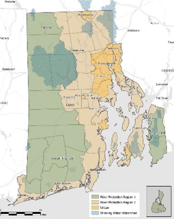
- Protection Standards: The new rules adopt a tiered protection approach to establishing buffer standards, with buffer zone widths ranging from 25 feet to 200 feet. This approach bases buffer zone widths on a combination of resource characteristics, watershed protection needs, and existing land uses. To implement this approach, the new rules divide the state into four regions: River Protection Region 1 (non-urban), River Protection Region 2 (non-urban), Urban Region, and Drinking Water Supply Watershed. RIDEM provides a Freshwater Wetlands Buffer Regions Map (shown left) to assist in identifying the regional divides.
- Buffer Zone Designations: In order to further protect critical resource areas, the new rules designate Buffer Zone Width by utilizing a combination of Region, general resource type, and resource specific data. In some cases this may be broken down by specific segment of a river or total acreage of a pond.
- Application Types: The new rules introduce a Freshwater Wetlands General Permit, intended for projects of predictable and limited potential impacts proposed with minimal or no alteration of buffer. The purpose of the General Permit is to provide a simplified application and streamlined review process for low impact projects which previously required more extensive permitting.
VERTEX HAS YOU COVERED
VERTEX has experienced engineers who have been providing environmental permitting services for site development projects throughout the United States. We understand the ever changing world of environmental regulations and our team of professionals have extensive experience working with regulatory agencies to successfully deliver projects with complex permitting needs.
To get in touch with a VERTEX expert regarding site development and regulatory permitting, please see the contact information below.
To learn more about VERTEX’s Civil Engineering Services, or to speak with a Forensic Expert, call 888.298.5162 or submit an inquiry.
Author: Gary DeBlois
REFERENCES


